Synopsis:
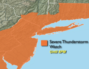
***A Severe Thunderstorm Watch is in effect until 8pm for the entire tri-state area. Severe thunderstorms contain winds in excess of 58mph and or one inch hail***
A cool front will approach today. A mix of smoky sun and clouds is expected. Temperatures will be seasonal in the mid 80s. Scattered storms are in the forecast through the afternoon and early evening.
Tonight will be cooler and much less humid.
The end of the week into the first part of the weekend will be comfortable with low levels of humidity and near seasonal readings in the mid 80s. High pressure will move from the Great Lakes to the East coast. Some fine July weather!
Sunday will see a return flow of Southerly air. This will result in an increase in humidity and also increase our chances of seeing afternoon scattered storms.
Stay tuned.
Keep it here for a no nonsense, no hype forecast.
Today:
Smoky sun and clouds. Humid. Scattered afternoon storms. Highs in the mid 80s. West to Northwest winds at 8-12mph.
Tonight:
An evening storm, otherwise becoming mostly clear and much cooler and less humid. Lows in the mid 60s in the City, the 50s inland. Northwest winds at 5-10mph.
Thursday:
Mostly sunny with low humidity. A top ten day! Highs in the lower 80s.
Friday:
Mostly sunny. Highs in the mid 80s.
Saturday:
Mostly sunny. Highs in the mid 80s.
Sunday:
Sun and clouds. Scattered afternoon storms. Humid. Highs in the mid 80s.