Synopsis:
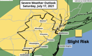
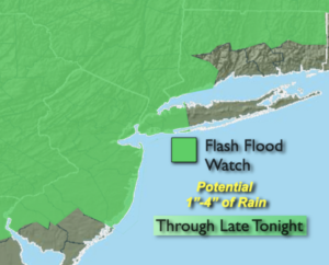
Today will be steamy with hazy sun. Scattered afternoon storms will develop. Keep an eye to the sky for threatening weather after 2pm. There is a slight risk of severe storms for much of the tri-state area. Severe storms contain winds in excess of 58mph and or one inch hail. Not all areas will get into the action this afternoon. Please keep an eye on the radar. The best threat of torrential rain and storms is between 6pm and midnight with a cool front. Some of the rain will cause flash flooding. A Flash Flood Watch has been posted for most of the region through late tonight. One to locally four inches of rain may fall. If you encounter a flooded roadway-TURN AROUND, DON’T DROWN. You don’t know how deep the water is.
The rain and storm will taper off later tonight. Skies will become partly cloudy.
Sunday will feature relief from the heat with readings staying below 90º. A mix of sun and clouds is expected. I am keeping it rain-free.
A Northwest flow will dominate for the beginning of the week. The heat will be on hiatus do to this setup. Tolerable conditions are expected into midweek under a mix of sun and clouds.
Stay tuned.
Keep it here for a no nonsense, no hype forecast.
Today:
Hazy, hot and humid. Scattered afternoon storms. Some of the storms maybe severe. Highs around 90º. Southeast winds at 5-10mph.
Tonight:
Scattered showers and storms with areas of torrential rain. Partly cloudy late. Lows in the lower 70s in urban areas, near 70º inland. Winds becoming Southwest less than 5mph.
Sunday:
Partly sunny, not as hot or humid. Highs in the mid 80s.
Monday:
Partly sunny. Highs in the lower to mid 80s.
Tuesday:
Partly sunny. Highs in the mid 80s.
Wednesday:
Partly sunny. Chance of a late day storm. Highs in the mid 80s.