Synopsis:
Heat and humidity will be with us through Saturday as a bubble of hot air remains in place around a Western Atlantic high pressure system.
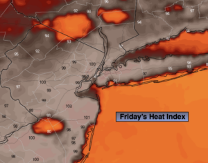
The heat will peak today. Skies will be mostly sunny. The heat index will around 100º in urban regions. An isolated late day storm is possible but most areas will remain storm-free.
Saturday will be steamy with hazy sun. Scattered afternoon storms are likely with an approaching cool front. The best chance for widespread storms looks to be later in the evening and at night.
The front looks to stall in the vicinity on Sunday resulting in spotty showers or storms. At this time it doesn’t look like a washout.
Monday and Tuesday will be decent with seasonal temperatures and lower humidity.
Stay tuned.
Keep it here for a no nonsense, no hype forecast.
Today:
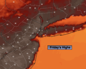
Hazy, hot and humid. Highs in the lower to mid 90s. Cooler along the immediate coast. Heat index: 100º+ in urban areas. Isolated late day storm. Southwest winds at 8-12ph.
Tonight:
An isolated storm early, otherwise partly cloudy, very warm and muggy. Lows in the upper 70s to around 80º in urban areas, near 70º inland. Winds becoming Northeast less than 5mph.
Saturday:
Hazy, hot and humid. Scattered afternoon storms. Highs around 90º.
Sunday:
Mostly cloudy, warm and humid. Spotty showers or storms.. Highs in the mid 80s.
Monday:
Partly sunny. Highs in the mid 80s.
Tuesday:
Partly sunny. Highs in the mid 80s.