
Synopsis:
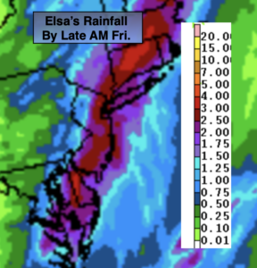
Tropical Storm Elsa will continue moving along our coast this morning. Areas of heavy rain along the coast will begin to taper off from West to East. Gusty winds will continue up to 45mph along the coast. These winds will diminish by midday. Depending on location, Elsa will drop between 1″-4″ of rain with the bullseye being areas East of I-95.
The sun will return by late morning to early afternoon depending on location. Readings will be near the average high of the mid 80s. The humidity will remain high.
The weekend will be more tranquil as high pressure will build in. This will result in mainly sunny skies Saturday and a mix of sun and clouds Sunday. It’ll be warm with low to moderate levels of humidity.
The heat and humidity will return for the beginning of the week as a Southerly flow once again takes hold around a Western Atlantic high pressure system. Hazy skies are expected with isolated afternoon storms.
Stay tuned.
Keep it here for a no nonsense, no hype forecast.
Today:
Morning heavy rain and gusty winds at the coast, otherwise becoming partly sunny. Humid. Highs in the mid 80s. Winds becoming Northwest winds at 15-30mph then becoming West to Southwest later in the day at 10-15mph.
Tonight:
Spotty evening storms, otherwise skies will be partly cloudy. Lows around 70º in the City, the 60s inland. North winds at 5mph.
Saturday:
Mostly sunny and warm. Highs in the mid 80s.
Sunday:
Partly sunny. Warm. Highs in the mid 80s.
Monday:
Partly sunny, warm and humid with spotty afternoon storms. Highs in the mid 80s.
Tuesday:
Partly sunny, very warm and humid with spotty afternoon storms. Highs in the upper 80s.