Synopsis:
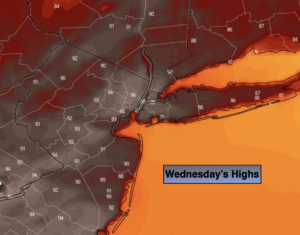
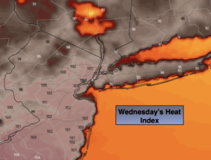
High pressure over the Western Atlantic will bring up a tropical airmass for much of the week. Hot & hazy conditions will continue today. The combination of temperatures in the 90s and high humidity will bring the heat index to over 100º+ in many areas. A Heat Advisory has been posted for much of the region. It will be cooler at the coast. Scattered late day storms are possible.
On Thursday, the bubble of hot air will move off the coast. This will bring relief from heat. Spotty late day storms are possible.
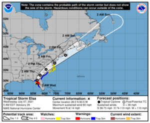
Tropical Storm Elsa is forecast to move up and just off or along the coast Thursday night and Friday morning. This is the timeframe when a quick hitting. period of heavy rain is possible. The exact track of Elsa will determine how much rain will fall and where the jackpot zone will be. Since the track is now closer to the coast. A period of strong winds is possible along the immediate coast of NJ and Central and Eastern Long Island (thinking possible gusts to 50mph at this time). High surf and dangerous rip currents are expected.
The storm will be a quick mover and the sun will return Friday afternoon.
The weekend will be a winner as high pressure will build in. This will result in mainly sunny skies and warm temperatures.
Stay tuned.
Keep it here for a no nonsense, no hype forecast.
Today:
Hazy, hot and humid. Spotty PM Storm. Highs in the lower to mid 90s. Heat Index: 98º-103º.
Tonight:
Spotty evening storm, otherwise partly cloudy, warm and muggy. Lows in the mid 70s in the City, the upper 60s inland. South to East winds at 5mph.
Thursday:
Warm and humid with scattered afternoon showers and storms. Highs in the mid 80s.
Friday:
Morning rain and gusty winds a the coast, otherwise becoming partly sunny. Highs in the lower to mid 80s.
Saturday:
Mostly sunny and warm. Highs in the mid 80s.
Sunday:
Mostly sunny and warm. Highs in the mid 80s.