Synopsis:
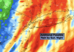
The forecast continues to be a raw one through Sunday of the Memorial Day weekend, with a glimmer of hope at the tail end-the holiday. It will be unseasonably chilly with readings in the 50s and 60s through Monday. On and off rain is expected through Sunday Night. Significant rainfall is expected East with lesser amounts West. This is all due to a second area of low pressure developing off the Maryland coast and moving Northeast slowly through Sunday.
High pressure over the Ohio Valley will hopefully turn a cloudy Memorial Day morning into a brighter afternoon. Fingers crossed, we can get that barbecue in!
Of course, drastic improvements will occur on Tuesday, June 1st. Sunshine and comfortable readings are expected.
Mild conditions are expected midweek with a shower threat by Thursday.
Stay tuned.
Keep it here for a no nonsense, no hype forecast.
Tonight:
Spotty showers becoming an on and off rain. Chilly and breezy. Lows in the 40s throughout. Northeast winds at 10-20mph with higher gusts along the coast.
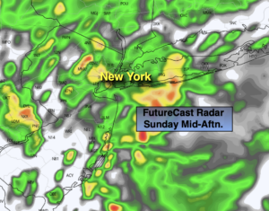
Sunday:
On and off rain. Unseasonably cool. Highs in the mid 50s. Northeast winds at 10-20mph.
Memorial Day:
Morning clouds giving way to some afternoon sun. Highs in the upper 60s.
Tuesday:
Sunny. Warmer. Highs in the mid to upper 70s.
Wednesday:
Partly sunny. Highs around 80º.
Thursday:
Mostly cloudy with showers. Highs in the mid 70s.