Synopsis:
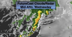
A cool front will move through the region during the day. The result will be a quick hitting period of showers from late morning through mid afternoon. The rain could come down heavy at times for a brief time. Temperatures will be well below the average high of 68º.
Skies will be mainly clear tonight as drier air work in from the Northwest.
Thursday will be the best day out of the bunch as high pressure dominates. Skies will be mainly sunny with pleasant readings.
Friday may start off with a bit of sun but clouds will roll in as low pressure develops offshore and upper level energy swings through. It now looks like the showers will hold off until night.
Mother’s Day Weekend will be bookended by a shower threat. Saturday will start off with showers as the upper level low moves off the coast. The sun should return during the afternoon. Mother’s Day will flip the forecast and start off with some sun. Clouds will roll in and showers are possible later in the day and evening as a warm front approaches. Much of the weekend will be rain-free. Temperatures both days will be cooler than average.
Stay tuned.
Keep it here for a no nonsense, no hype forecast
Wednesday:
Showers likely from late morning though mid-afternoon (Eastern areas will experience the rain a bit longer). Cool. Highs in the lower 60s. Northeast to Northwest winds at 5-10mph.
Tonight:
Mostly clear. Lows in the 40s to around 50º in the City. Northwest winds at 10-20mph.
Thursday:
Mostly sunny. Highs in the mid 60s.
Friday:
Sun to clouds. Highs in the lower to mid 60s.
Saturday:
Morning showers, otherwise becoming partly sunny. Highs in the lower to mid 60s.
Mother’s Day:
Morning sun, otherwise becoming mostly cloudy. Showers are possible by evening. Highs in the lower to mid 60s.