Synopsis:
A fine stretch of days are anticipated into midweek. Strong high pressure will be in control. This system will turn into a warm air pump as a Southwesterly flow develops. Readings will get to well above average by midweek. A Summer feel is on the way.
The jury is out whether a cool front will sag to our South on Thursday. If it pushes South temperatures will cool down. If it remains to our North our Summer preview will continue. At this time, I’ll continue with the June-like readings under a mix of sun and clouds. A spot PM Shower is possible.
On Friday the front will push through. An isolated shower is possible early on. Temperatures will still be several degrees above the average highs of the mid 60s.
Stay tuned.
Keep it here for a no nonsense, no hype forecast.
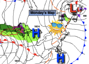
Monday:
Mostly sunny and breezy. Highs in the lower 60s. Northwest 10-20mph.
Tonight:
Mostly clear and cool. Lows the mid 40s in the City, the 30s to lower 40s inland. Northwest winds diminishing to 5-10mph.
Tuesday:
Mostly sunny and warmer. Highs in the lower 70s.
Wednesday:
Sunny. Much warmer. Highs in the lower to mid 80s.
Thursday:
Sun and clouds. Warm. Spotty afternoon showers possible. Highs around 80º.
Friday:
Sun and clouds. Cooler. Isolated morning showers possible. Highs around 70º.