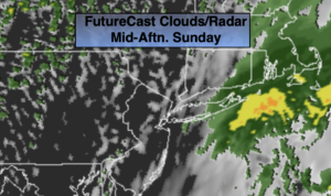
Synopsis:
Low pressure off the NJ coast will result in a soggy start to Sunday but the good news the storm is it’s moving rapidly. The rain will taper off from West to East from mid-morning through early afternoon. The sun should make an appearance during the day. Readings will be a few degrees below the average high of 64º.
Tonight will be mainly clear and cool.
A fine stretch of days are anticipated into midweek. Strong high pressure will be in control. This system will turn into a warm air pump as a Southwesterly flow develops. Readings will get to well above average by midweek. A June feel is on the way.
The jury is out whether a cool front will sag to our South on Thursday. If it pushes South temperatures will cool down. If it remains to our North our Summer preview will continue. At this time I’ll take the middle of the road and call for a slight cool off with a chance of spotty showers Thursday afternoon with the approaching front.
Stay tuned.
Keep it here for a no nonsense, no hype forecast.
Today:
Rain likely during the morning. The rain will taper off from West to East toward midday. A mix of sun and clouds is expected for the afternoon. Highs in the lower 60s. Northeast to Northwest winds at 8-12mph.
Tonight:
Mostly clear and cool. Lows the mid 40s in the City, the 30s to lower 40s inland. Northwest winds at 10-20mph.
Monday:
Mostly sunny. Highs in the lower to mid 60s.
Tuesday:
Sunny and warmer. A top ten day. Highs in the lower 70s.
Wednesday:
Sunny. Much warmer. Highs in the lower 80s.
Thursday:
Sun and clouds. Spotty afternoon showers possible. Highs in the mid 70s.