Synopsis:
High pressure originating in Canada will influence our weather tonight into Wednesday. Temperatures will get well below freezing overnight with a refreeze of slush and water. Skies will be mostly clear.
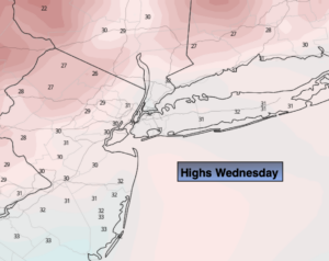
Bright, but cold conditions are expected Wednesday. I don’t think too many will mind the cold, as long as the sun is shining. High clouds will work in later in the day.
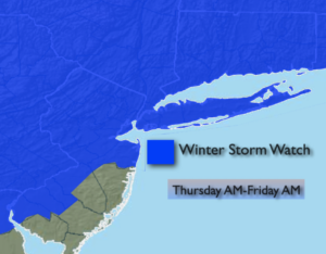
The next storm in this parade will be Thursday into Friday. This also looks to be a significant precipitation producer. The potential is there for front end thump of accumulating snow Thursday. The snow should start sometime in the early morning and could quickly become heavy for a time into the afternoon. Once again, the track of the storm will be very close to the region. This should change the snow to sleet and or freezing rain and rain later in the day Thursday or Thursday night, especially closer to the coast.
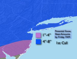
The storm will be a slow mover and take its time moving out to sea on Friday. Occasional light snow or a mix is expected into the afternoon. Total possible accumulations with the first call map are above. Lighter amounts are expected over Southern NJ with more of a mix in that region. These amounts will change as we get closer to the event. Yep, another potential plowable snow is expected.
The weekend looks bright and chilly.
Stay Tuned.
Keep it here for a no nonsense, no hype forecast.
Tonight:
Clear and much colder. Lows in the mid 20s in the City, the teens and lower 20s inland. West to Northwest winds at 10-20mph.
Wednesday:
Mostly sunny. Cold. Highs in the upper 20s to around freezing. Northwest winds at 8-12mph.
Thursday:
Snow. Possibly heavy at times. A mix to sleet and freezing rain is likely later in the day and at night, especially South and East. Highs in the 20s to around freezing.
Friday:
Occasional light snow or a mix. Highs in the mid 30s.
Saturday:
Partly sunny. Cold. Highs around freezing.
Sunday:
Sunny. Cold. Highs in the lower to mid 30s.