Synopsis:
An Arctic blast will continue grip the area into the weekend as Canadian high pressure influences the region. Please dress in layers. The layers tend to deaden the air in between and in turn keep your body warm.
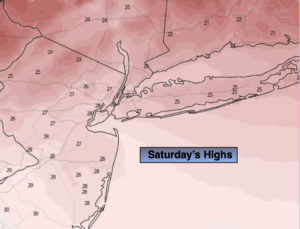
Today the winds will abate as the cold high settles over the area. Abundant sunshine is expected with readings remaining below freezing.
By Sunday, all eyes will turn to a developing system to our South. Early morning sun will give way to increasing and thickening clouds. Light snow may develop toward dark over Central and Southern NJ. Snow should overspread most of the region Sunday night. The exception maybe the Northwestern counties.
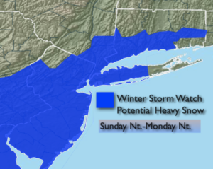
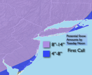
The potential has increased significantly for snow Monday and early Tuesday. The computer models are in much better agreement that a storm will form off the Mid-Atlantic coast on Monday and only slowly drift up and off our coastline through Tuesday. Could this be a classic snowstorm, yes, if all of the storm remains on it’s projected track. The sharp cutoff of the accumulating snow over the region now looks to be only be over Eastern Long Island and Coastal Ocean county. A mix may occur here. The threat is there for heavy snow for a majority of the region. A Winter Storm Watch is up now for most of the tri-state area (first map above). The “first call” snow amounts have been posted above. 8″-14″ of snow is possible for much of the region. These amounts are not set in stone and most likely will change, but confidence has increased on heavy snow for much of the region.
The storm will likely be of long duration and contain high winds. Winds could gusts over 50mph at the coast. I will not use the “B” word-yet. Coastal flooding is also possible.
Again, this is for Sunday night through Tuesday Morning.
Stay Tuned.
Today:
Sunny and cold. Highs in the upper 20s. Northwest winds at 10-20mph.
Tonight:
Clear. Frigid. Lows around 20º in the City, the single digits and teens inland. North winds at 5mph.
Sunday:
Thickening clouds. Light snow possible toward dark South of the City. Highs around 30º.
Monday:
Snow likely. Windy. Highs in the upper 20s.
Tuesday:
Chance of snow in the morning. Windy. Highs around 30º.
Wednesday:
Partly sunny. Windy. Highs in the mid 30s.