Synopsis:
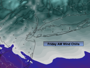
Tonight will be the coldest night of the season so far as Arctic high pressure moves in from the North. Wind chills in most regions morning will be below zero. Well to the North Wind chills will be between -10 to -20º (1st map above).
Please dress in layers during this bitter blast. The layers tend to deaden the air in between and in turn keep your body warm.
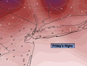
Frigid air will continue to funnel in on Friday. Mainly sunny skies are expected with a biting wind.
On Saturday the winds will have abated some as the cold high settles over the region. Abundant sunshine is expected with readings remaining below freezing.
By Sunday, all eyes will turn to a developing system to our South. Sun should give way to increasing afternoon clouds. I am continuing to keep Sunday afternoon snow-free.
The potential has increased for snow Monday and Tuesday. It all depends on the track a storm that will be developing off the Mid-Atlantic coast and where the heavy axis of snow sets utp. Could this be a classic snowstorm, yes, if all of the ingredients come together. Remember this is a potential and not a certainty. Some rain is also a possible over Southern sections. The threat is there for this system to be of long duration and contain high winds. We’ll fine tune the forecast and give more details as time goes on.
Stay Tuned.
Tonight:
Clear, frigid and windy. Lows in the mid teens in the City, near 10º inland. Northwest winds at 15-30mph. Wind chills near 0º or below.
Friday:
Mostly sunny, windy and very cold. Highs only in the lower to mid 20s. Wind chills in the single digits and teens. Northwest winds at 15-3omph.
Saturday:
Sunny and cold. Highs in the upper 20s.
Sunday:
Sun to clouds. Highs around 30º.
Monday:
Chance of snow. Highs around 30º.
Tuesday:
Chance of snow. Highs around 30º.