Synopsis:
This has to be one of the most tranquil weather patterns for January I’ve seen in some time (not too cold, nor stormy). Low pressure continues to move into the Atlantic as high pressure settles in over the central and Eastern part of the nation. The winds will relax some today. It won’t be as harsh with readings above average by a few degrees.
Conditions Friday through the weekend will be mainly sunny with seasonal temperatures as high pressure dominates.
The models after the next 5 days are all over the place with the overall pattern and placement of systems. The next time frame to watch will be Tuesday into Wednesday. A trough will swing through the Eastern Seaboard. Where a storm develops and if it affects our weather is yet to be seen.
Stay Tuned.
Keep it here for a no nonsense, no hype forecast.
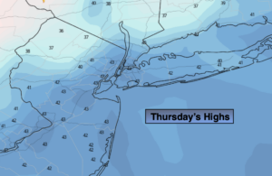
Today:
Mostly sunny. Highs in the lower to mid 40s. Northwest winds at 8-12mph with gusts to 20mph.
Tonight:
Mostly clear. Cold. Lows around freezing in the City, the teens and 20s inland. North/Northwest winds at 5-10mph.
Friday:
Mostly sunny. Highs in the upper 30s to lower 40s.
Saturday:
Mostly sunny. Highs in the upper 30s.
Sunday:
Sunny. Highs around 40º.
Monday:
Mostly sunny. Highs around 40º.