Synopsis:
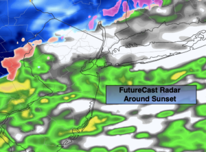
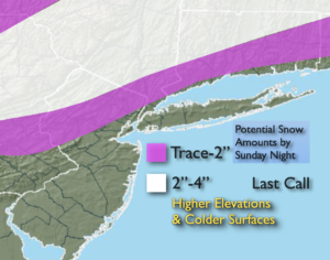
Low pressure will develop off the Mid-Atlantic coast today. There will be 2 rounds of precipitation. Round one will be this morning. Then there will be a break in the action for several hours. Round 2 develops toward sunset (1st map). Any snow that potentially may accumulate, will occur over the higher elevations and on colder surfaces. This continues to look like a minor snowfall for inland areas. Last call amounts are above.
The precipitation will continue overnight and become light and intermittent.
The beginning of the work and school week looks quiet as low pressure moves to the Canadian Maritimes and high pressure settles in over the central part of the nation. Readings will be just above average under a mix of clouds and some sun. It looks like the clouds will dominate. The wind will be busy Tuesday and Wednesday, but readings will be several degrees above the average high of 39º.
By late week high pressure move in. The winds will relax and the skies will be brighter.
Stay Tuned.
Keep it here for a no nonsense, no hype forecast.
Today:
2 rounds of precipitation depending on location. Round 1 will occur this morning. Then there will be a break for several hours. Round 2 will occur toward sunset. Highs in the lower to mid 40s, 30s inland. Northeast winds at 8-12mph.
Tonight:
Areas of rain, sleet and light snow ending late. Lows in the mid 30s in the City, around freezing inland. North to Northeast winds at 5-10mph.
Monday:
Clouds to some sun. Highs in the mid 40s.
Tuesday:
Mostly cloudy. Breezy. Highs in the lower to mid 40s.
Wednesday:
Partly sunny. Breezy. Highs in the lower to mid 40s.
Thursday:
Mostly sunny. Highs in the lower 40s.