Synopsis:
Partly cloudy skies are expected overnight.
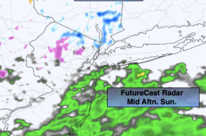
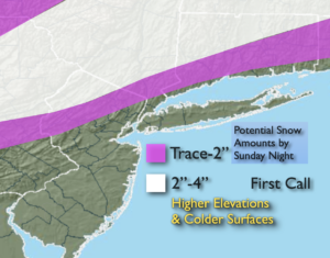
Low pressure will develop off the Mid-Atlantic coast on Sunday. Thickening clouds are expected during the morning. Scattered showers of rain, sleet and wet snow are expected through mid-afternoon. The steadier precipitation will hold off until later in the afternoon and into the evening. Any snow that potentially may accumulate, will occur over the higher elevations and on colder surfaces during the evening and at night. This continues to look like a minor snowfall for inland areas. First call amounts are above.
The beginning of the work and school week looks tranquil as low pressure moves to the Canadian Maritimes and high pressure settles in over the central part of the nation. Readings will be just above average under a mix of sun and clouds. The wind will be busy Tuesday and Wednesday, but readings will be several degrees above the average high of 39º.
Stay Tuned.
Keep it here for a no nonsense, no hype forecast.
Tonight:
Partly cloudy. Lows in the mid 30s in the City, the 20s inland. Northwest to Northeast winds at 5-10mph.
Sunday:
Thickening clouds. Scattered showers. Areas of light sleet and or wet snow inland. There will be dry times. The steadier and heavier precipitation will hold off until sunset. Highs in the lower to mid 40s, 30s inland. Northeast winds at 8-12mph.
Monday:
Clouds to sun. Highs in the mid 40s.
Tuesday:
Partly sunny. Breezy. Highs in the lower to mid 40s.
Wednesday:
Partly sunny. Breezy. Highs in the lower to mid 40s.
Thursday:
Mostly sunny. Highs in the lower 40s.