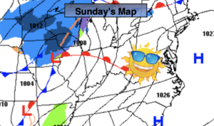
Synopsis:
High pressure will dominate the East coast. This will result in abundant sunshine and seasonal readings. The average high is 40º.
Tonight will be partly cloudy and not as cold as recent night in urban areas. Lows will be in the mid 30s in the City, the teens and 20s inland.
A mix of sun and clouds are expected for Monday as a weak low moves well to our North and West. A Southwesterly flow around this system will pop the temperatures well into the 40s.
Tuesday and Wednesday will be bright but colder as high pressure moves in from the West.
The next chance of precipitation will be about the time we ring in the new year. Late New Year’s Eve into Friday New Year’s Day a complex low with its associated fronts will move to the Eastern Seaboard. The setup is a mild one, so it looks wet and not white.
Stay Tuned.
Keep it here for a no nonsense, no hype forecast.
Today:
Sunny and seasonal. Highs near 40º. West to Southwest winds at 5mph.
Tonight:
Partly cloudy. Lows in the mid 30s in urban areas, the teens & 20s inland. South winds at 5mph.
Monday:
Partly sunny. Milder. Highs in the mid to upper 40s.
Tuesday:
Sunny. Colder. Highs in the mid 30s.
Wednesday:
Sunny. Seasonal. Highs around 40º.
New Year’s Eve:
Increasing clouds. Much milder. Chance of afternoon showers. Highs in the mid 50s.