Synopsis:
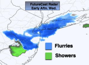
A weak disturbance will move out of the Eastern Great Lakes and through our region today. This will result in more clouds and possible flurries. Readings will be around five degrees colder than the average high of 45º.
Skies will become mostly clear later tonight with readings remaining above freezing in urban areas.
On Thursday, temperatures will finally get above average with abundant sun as a West to Southwest wind develops as high pressure moves over the Southeastern states. Hanukkah begins at sundown Thursday.
Friday also looks like a winner with abundant sunshine with highs near 50º.
The weekend will be Spring-like. A mix of sun and clouds is expected Saturday. By afternoon a moist Southerly wind may throw scattered showers our way-the majority of the day will be dry.
A front will approach Saturday night and Sunday morning with showers. If all works out, we should have a decent Sunday afternoon. It’ll still be mild as there is no cold air behind the front.
Stay Tuned.
Keep it here for a no nonsense, no hype forecast.
Today:
More clouds than sun, scattered flurries. High around 40º. West winds at 8-15mph.
Tonight:
Clearing skies. Lows in the mid 30s in the City, the 20s inland. West winds at 8-12mph.
Thursday:
Mostly sunny. Milder. Highs near 50º.
Friday:
Sunny. Highs around 50º.
Saturday:
Sun and clouds. Scattered afternoon showers possible. Mild. Highs in the mid 50s.
Sunday:
Morning showers should give way to some afternoon sun. Still mild. Highs in the mid 50s.