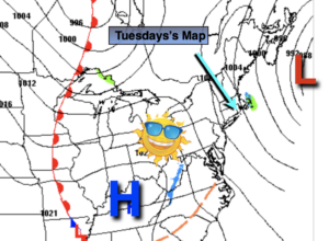
Synopsis:
A storm over the Canadian Maritimes and high pressure over the Tennessee Valley will cause the pressure gradient to be tight today. All this means in layman terms is the wind will be busy and will add a bite as readings will be hard pressed to reach 40º. Skies will start off grey but the sun will win the battle by afternoon.
Tonight will be mainly clear with all readings below freezing. Winds will diminish.
A weak disturbance will move out of the Eastern Great Lakes and through our region on Wednesday. This will result in more clouds and possible flurries. The sun will shine more so later in the day.
By Thursday, temperatures will finally get just above average with abundant sun as a West to Southwest wind develops as high pressure moves over the Southeastern states. Hanukkah begins at sundown Thursday.
Friday also looks like a winner with readings a few degrees above the average high of 48º.
The weekend will start off mild with a mix of sun and clouds.
Stay Tuned.
Keep it here for a no nonsense, no hype forecast.
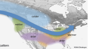
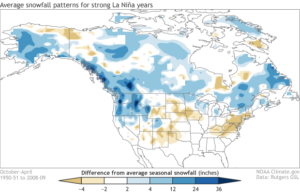
A strong La Nina pattern will be occurring this Winter. I’m not the biggest fan of long range, but thought I’d share with you a couple of graphics. Yes, snowfall is typical below below average, but all it takes is that “right” setup for a snowstorm.
Today:
Mostly sunny and breezy. High around 40º in urban areas, the 30s inland. Wind chills near freezing. Northwest winds at 10-20mph with gusts to 25mph.
Tonight:
Clear and cold. Lows around 30º in the City, the 18º to 25º inland. Northwest winds at 5-10mph.
Wednesday:
Clouds and sun with scattered flurries. High in the lower 40s.
Thursday:
Mostly sunny. Milder. Highs near 50º.
Friday:
Sunny. Highs around 50º.
Saturday:
Partly sunny. Mild. Highs in the mid 50s.