Synopsis:
Today will definitely be the better half of the weekend. High pressure will move into Northern New England. The cold air with this system will remain to our North but supply the region with abundant sunshine- it will be mild. This same high will increase our clouds tonight and introduce the chance of on and off light rain or drizzle durning Sunday afternoon as the wind turns in off the ocean. Sunday will be a much cooler day than today with readings remaining several degrees below the average high of 52º.
A few showers are possible on Monday with an approaching front. The sun should return during the afternoon.
Tuesday will be bright and cool with another area of high pressure moving in.
A cool front will approach on Wednesday with any sun giving way to clouds. At this time, the Thanksgiving forecast will include showers as a front moves through. Whether it’s a quick moving system or an all day rain remains to be seen.
Stay Tuned.
Keep it here for a no nonsense, no hype forecast.
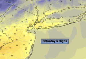
Today:
Partly sunny. Mild. Highs around 60º. Northwest winds at 5-10mph.
Tonight:
Increasing clouds. Lows around 40º in urban areas, the 30s inland. North to Northeast winds at 5-10mph.
Sunday:
Cloudy. Much cooler. On and off light rain or drizzle is possible during the afternoon. Highs in the upper 40s.
Monday:
Morning showers, afternoon sun. Highs in the mid 50s.
Tuesday:
Sunny. Chilly. Highs in the upper 40s.
Wednesday:
Sun to clouds. Highs in the mid 50s.