Synopsis:
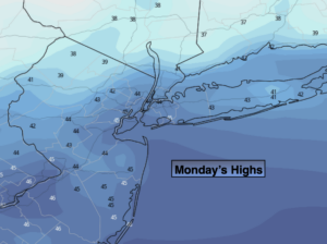
The coldest airmass of the season so far will greet us today on a strong wind. Wind gusts up to 45mph are expected. Secure any loose objects outdoors. A mix of sun and clouds is expected with readings at least fifteen degrees below the average high of the upper 50s. Strong low pressure in Eastern Canada and high pressure over the Mid-West will result in a tight pressure gradient. This is the cause of the gusty winds.
Tonight will be mostly clear and cold with readings in the 30s. The wind will still be howling though not as strong as today.
Chilled sunshine is in the forecast for Tuesday as high pressure moves in. The winds will ease some. Wednesday will be more seasonal as high pressure slips to the Southeast.
By Thursday and Friday it will be mild with temperatures reaching into the 60s. The sun will continue to dominate.
Stay Tuned.
Keep it here for a no nonsense, no hype forecast.
Today:
Partly Sunny, windy and cold. Highs only in the lower to mid 40s. Wind chills will be in the 30s. West to Northwest winds at 15-30mph with gusts to 45mph.
Tonight:
Mostly clear, breezy and cold. Lows in the upper 30s in the City, near 30º inland. West to Northwest at 15-30mph.
Tuesday:
Mostly Sunny, breezy and chilly. The winds will ease some. Highs in the upper 40s to around 50º.
Wednesday:
Sunny and seasonal. Highs in the mid to upper 50s.
Thursday:
Sunny, mild. Highs in the lower 60s.
Friday:
Sunny, mild. Highs in the mid 60s.