Synopsis:
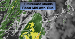
Clouds will dominate for November’s debut. Showers are likely during the afternoon as low pressure develops just offshore ahead of an approaching cold front. A steadier period of rain is likely later in the day for a couple of hours. The sun will set an hour earlier this afternoon at 4:51PM as Eastern Standard Time has resumed.
Skies will clear tonight and it will become windy and cold behind the front and an intensifying storm over Eastern Maine.
The coldest airmass of the season so far will arrive on Monday on a strong gusty wind. A mix of sun and clouds is expected.
Chilled sunshine is in the forecast for Tuesday as high pressure moves in. Wednesday will be more seasonal as high pressure slips to the Southeast. The sun will continue to dominate. By Thursday readings will get above the seasonal average of 58º.
Stay Tuned.
Keep it here for a no nonsense, no hype forecast.
Today:
Mostly cloudy with afternoon showers developing. A period of rain is likely later in the day for a couple of hours. Highs in the mid to upper 50s. South winds at 8-12mph.
Tonight:
Clear, windy and cold. Lows in the upper 30s in the City, near 30º inland. West to Northwest at 15-30mph with higher gusts.
Monday:
Partly Sunny, windy and cold. Highs only in the mid 40s.
Tuesday:
Mostly Sunny. Chilly. Highs in the upper 40s.
Wednesday:
Sunny and seasonal. Highs in the mid 50s.
Thursday:
Sunny, mild. Highs in the lower 60s.