Synopsis:
High pressure will dominate our weather through Sunday. Skies will be mainly sunny. Readings be cool to start but moderate once again into the 70s during the weekend. We’re keeping Sunday dry at this time as the remnants of Hurricane Delta move North into the Tennessee Valley and high pressure keeps us locked in with fair weather. A period of rain or showers is possible Sunday night and Monday with Delta’s remnants.
Stay Tuned.
Keep it here for a no nonsense, no hype forecast.
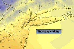
Today:
Mostly sunny, breezy and cooler. Highs in the lower to mid 60s. Northwest winds at 10-20mph with higher gusts.
Tonight:
Clear with diminishing winds. Chilly. Lows around 50º in the City, the 30s and 40s inland. Northwest winds at 5mph or less.
Friday:
Sunny. Highs in the mid to upper 60s.
Saturday:
Sunny. Warmer. Highs in the lower to mid 70s.
Sunday:
Sun and clouds. Highs in the lower 70s.
Monday:
Mostly cloudy with scattered showers. Highs in the mid 60s.