Synopsis:
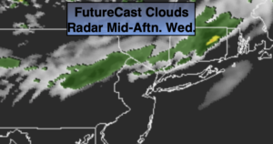
High pressure will dominate our weather through this afternoon. It will be mainly sunny and warm. A cool front will approach during late day, clouds will increase and winds will become gusty. Winds gusts could reach 45mph out of the West. A spot evening shower can’t be ruled out with the passage of the front. It will feel like mid September with readings in the mid 70s. The average high is 67º.
High pressure will dominate Thursday through Sunday. Skies will be mainly sunny. Readings be cool to start but moderate once again into the 70s during the weekend. We’re keeping Sunday dry at this time as the remnants of Hurricane Delta move North into the Tennessee Valley and high pressure keeps us locked in with fair weather.
Stay Tuned.
Keep it here for a no nonsense, no hype forecast.
Today:
Mostly sunny, warm and becoming windy. Clouds will move in late day with a spot shower possible during the evening. Highs in the mid 70s. Southwest to West winds at 10-20mph increasing to 15-30mph with gusts to 45mph later in the day.
Tonight:
Clear with diminishing winds later in the evening. Lows in the lower 50s in the City, the 40s inland. Northwest winds at 15-25mph with gusts to 45mph early. Winds diminishing to to 10-20mph late.
Thursday:
Mostly sunny, cooler. Highs in the mid 60s.
Friday:
Sunny. Highs in the mid 60s.
Saturday:
Sunny. Warmer. Highs in the lower to mid 70s.
Sunday:
Sun and clouds. Highs in the lower 70s.