Synopsis:
A cool front will sweep offshore early this morning ending any leftover rain. It will become mostly sunny. Winds will pick up and become gusty. Temperatures will be near the seasonal averages of the lower 70s.
Tonight will be clear and much cooler than recents nights.
Thursday will feature mainly sunny skies as high pressure moves over the area. Friday will be partly cloudy with scattered mainly morning showers as a weak low develops over the region and moves into New England. It’ll be much cooler.
The first weekend of October will be bright and chilly as high pressure influences the area from Canada.
Stay Tuned.
Keep it here for a no nonsense, no hype forecast..
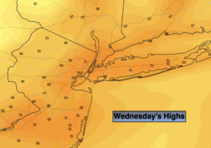
Today:
Early morning rain East, otherwise becoming mostly sunny, breezy and seasonal. Highs in the lower 70s. West winds at 15-25mph with gusts over 30mph.
Tonight:
Clear and cooler. Diminishing winds. Lows in the upper 50s in the City, the upper 40s and 50s inland. Southwest to West diminishing to 5-10mph.
Thursday:
Mostly sunny. Highs in the lower 70s.
Friday:
Mostly cloudy. Scattered morning showers possible. Cooler. Highs in the mid 60s.
Saturday:
Mostly sunny. Cool. Highs in the mid 60s.
Sunday:
Mostly sunny. Highs in the mid 60s.