Synopsis:
The sun will return today and dominate the sky as the remnants of Sally pull away from the Mid-Atlantic coast and high pressure starts influencing out weather. Readings today will be several degrees below the average high of 75º. It will be breezy.
Tonight will be clear and very chilly. The coldest night of September so far is on the way. Grab that blanket.
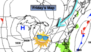
Strong high pressure located over the Great Lakes and Canada will supply the region unseasonably cool and sunny conditions through the weekend and into the beginning of next week. A Fall preview is on the way. Temperatures will be ten degrees below average for highs. Autumn offically arrives on Tuesday.
Stay Tuned.
Keep it here for a no nonsense, no hype forecast.
Today:
Mainly sunny skies. Cooler and breezy. Highs around 70º. North wind at 10-20mph with higher gusts.
Tonight:
Clear and very chilly. Lows in the upper 40s in urban areas, the upper 30s and 40s inland. North wind at 10-20mph.
Saturday:
Sunny. Cool. Highs in the mid 60s.
Sunday:
Sunny. Cool. Highs in the lower to mid 60s.
Monday:
Sunny. Cool. Highs in the mid 60s.
Tuesday:
Sunny. Highs around 70º.