Synopsis:
High pressure will dominate the Northeastern states through Thursday. This will result in pleasant temperatures today and abundant sunshine. Readings will be a few degrees below the average high of 76º. The sun will rule the sky through Thursday with moderating temperatures as the high slips offshore. You probably noticed a deep haze to the skies. This is not clouds but smoke that has traversed the entire country due to the wild fires out West!
The remnants of Hurricane Sally will pass well to our South bring some clouds our way on Friday. A mix of sun and clouds is expected. At the same time a significant cold front will move through (rain-free). Another shot of Canadian air will reach the region later Friday and into the weekend. The coolest temperatures of the month will be with us this last weekend of Summer. Fall arrives on Tuesday.
Stay Tuned.
Keep it here for a no nonsense, no hype forecast.
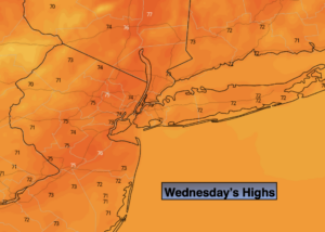
Wednesday:
Sunny, smoky skies. Highs in the lower to mid 70s. South to Southwest winds 8-12mph.
Tonight:
Mostly clear and cool. Lows in the lower 60s in urban areas, the upper 40s & 50s inland. Southwest wind at 5mph.
Thursday:
Partly sunny, warmer. Highs in the upper 70s.
Friday:
Partly sunny, cooler and breezy. Highs in the upper 60s.
Saturday:
Sunny. Cool. Highs in the mid 60s.
Sunday:
Sunny. Cool. Highs in the mid 60s.