Synopsis:
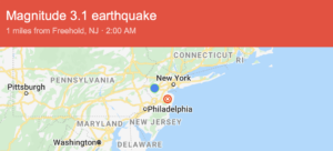
***A magnitude 3.1 earthquake occurred this today at 2am. The epicenter was East Freehold. Many in the area felt it***
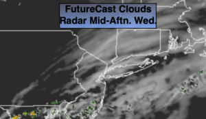
High pressure will move off the coast and the wind will blow off the ocean. This will result in more clouds than sun. A few scattered coastal showers are possible later in the day. Readings will be above the average high of 78º by a few degrees.
A weak low will ride along the Mid-Atlantic coast tonight and Thursday at the same time a cool front will be approaching. Scattered showers and storms are likely tonight and Thursday.
High pressure will build in from Canada on Friday. Skies will become mostly sunny and seasonal temperatures are expected with much lower humidity. The beginning of the weekend will have a Fall feel under mainly sunny skies. Saturday will be the better half of the weekend. Sunday’s forecast includes the threat of showers and storms as a front approaches.
Stay Tuned.
Keep it here for a no nonsense, no hype forecast.
Today:
Clouds, some sun at times. Isolated afternoon coastal showers. Highs in the lower 80s. East winds at 5mph.
Tonight:
Cloudy and muggy. Scattered showers and storms possible. Lows around 70º in the City, the 60s inland. East winds at 5mph.
Thursday:
Scattered showers and storms. Humid. Highs in the upper 70s.
Friday:
Mostly sunny and less humid. Highs in the upper 70s.
Saturday:
Mostly sunny. Cool. Highs in the mid 70s.
Sunday:
Scattered showers and storms possible. Highs in the upper 70s.