Synopsis:
High pressure will move over the region through Friday and into the Atlantic this weekend. Today will be a top ten day. Wall to wall sunshine is expected with comfortably warm readings and low humidity. A get outdoors day!
Tonight, like last night, will be cool. Readings will once again dip into the 50s inland.
Mainly sunny skies are expected with moderating temperatures into the weekend as the wind blows from the Southwest. The humidity will be in check through Friday but begin to creep up through the weekend. A spot afternoon storm can’t be ruled out on Sunday. Enjoy!
Stay Tuned.
Keep it here for a no nonsense, no hype forecast.
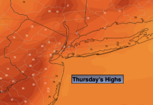
Today:
Sunny. Highs around 80º. Northeast to South winds at 5-10mph.
Tonight:
Clear and cool. Lows in the mid 60s, the 50s inland. Southwest winds at 5mph or less.
Friday:
Sunny. Highs in the mid 80s.
Saturday:
Hazy, warm and humid. Highs in the mid to upper 80s.
Sunday:
Hazy, warm and humid. Isolated afternoon storms. Highs in the mid to upper 80s.
Monday:
Hazy, Hot and humid. Highs near 90º.