Synopsis:
The haze, heat and humidity will stick around through today. This is courtesy of a Bermuda high. A weak trough of low pressure will also be over the region causing scattered afternoon storms. The storms will be slow moving. This will result in torrential rain in spots. A Flash Flood Watch has been posted for areas just West of the City through this evening. Not all areas will get into the action. The storms will taper off this evening.
A cool front will approach on Thursday. Skies will be mainly cloudy . Temperatures will be cooler do to the clouds and scattered showers and storms expected.
Friday’s forecast has changed for the better. The front now looks to push offshore far enough to keep much of the rain to the South. Clouds will give way to sunshine with much lower levels of humidity.
The weekend is looking bright and comfortable with readings actually a couple degrees below the average of 83º. High pressure over Eastern Canada will be responsible for our August delight.
Stay Tuned.
Keep it here for a no nonsense, no hype forecast.
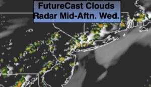
Wednesday:
Hazy, very warm and humid. Scattered afternoon storms. Highs in the upper 80s to around 90º. Light and variable winds around 5mph.
Tonight:
A spotty evening storm, otherwise partly cloudy and muggy. Lows in the lower 70s in urban areas, the 60s inland. Northeast winds at 5mph or less.
Thursday:
Mostly cloudy. Cooler. Scattered showers and afternoon storms. Highs in the lower 80s.
Friday:
Clouds to sun. Much less humid. Highs in the lower to mid 80s.
Saturday:
Sunny and comfortable. Highs in the lower 80s.
Sunday:
Mostly sunny. Highs in the upper 70s to around 80º.