Synopsis:
It will be hot but much less humid today as drier air has worked in from the North. The sun will dominate. The humidity will return tonight as the wind once again goes South. With this push of humid air scattered showers and storms are possible late tonight and early Wednesday morning, especially to the North. The threat of scattered storms will exist Wednesday afternoon and then again on Thursday in the unstable airmass. It will not be a washout and hazy sun is expected both days as weak high pressure off the Southeast coast supplies our tropical feel.
Relief from the heat and humidity will arrive on Friday behind a cool front. Skies will be mainly sunny.
The weekend at this time looks decent with plenty of sun, warm readings and tolerable levels of humidity.
Stay Tuned.
Keep it here for a no nonsense, no hype forecast.
Today:
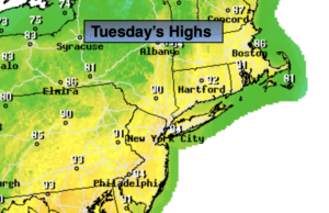
Sunny and hot. The humidity will be at lower levels. Highs in the lower to mid 90s. Winds becoming South at 5-10mph.
Tonight:
Partly cloudy, warm and becoming more humid. Scattered late night showers and storms are possible, especially North. Lows in the mid to upper 70s in urban areas, the upper 60s and lower 70s inland. Light Southeast winds.
Wednesday:
Hazy, warm and humid. Early isolated showers or storms. Spotty PM Storms. Much of the time will be dry. Highs in the upper 80s.
Thursday:
Hazy, hot and humid. Spotty PM Storms. Highs around 90º.
Friday:
Mostly sunny. Less humid. Highs in the mid to upper 80s.
Saturday:
Mostly sunny. Highs in the mid to upper 80s.