Synopsis:
A heatwave will grip much of the East coast beginning today. The 3 H’s will be back and hot conditions will continue into next week as a Bermuda high takes hold. Abundant sunshine is expected with no threat of storms through the weekend.
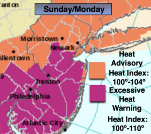
Heat Advisories and Excessive Heat Warnings have been posted. The combination of temperatures in the 90s and high dew points will result in a heat index of 100º or higher.
Please drink plenty of fluids and listen to your body. If you feel weak take a break.
Stay Tuned.
Keep it here for a no nonsense, no hype forecast.
Today:
Hazy, hot and humid. Highs in the lower 90s. Heat Index 95º-100º. Winds becoming South at 5-10mph.
Tonight:
Partly cloudy. Much warmer than recents nights. Muggy. Lows in the mid to upper 70s in the City, the upper 60s inland. Light South winds.
Sunday:
Hazy, hot and humid. Highs in the mid 90s. Heat index around 100º-110º.
Monday:
Hazy, hot and humid. Scattered afternoon storms. Highs in the mid 90s. Heat Index: 100º-110º
Tuesday:
Hazy, hot and humid. Highs in the lower 90s. Heat Index: 95º-102º.
Wednesday:
Hazy, hot and humid. Highs around 90º.