Synopsis:
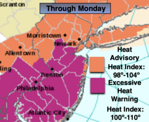
A heatwave will continue to grip the tri-state area. The 3 H’s will be with us into the week as a Bermuda high dominates. Heat Advisories and Excessive Heat Warnings have been posted. The combination of temperatures in the 90s and high dew points will result in a heat index of 100º through Monday. Abundant sunshine is expected with no threat of storms today.
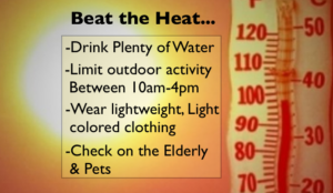
“Beat the heat” tips are above. Please drink plenty of fluids and listen to your body. If you feel weak take a break.
The heat will peak on Monday. A spot storm is possible later in the day.
Less humid conditions are expected Tuesday. But true relief from the hot temperatures won’t most likely arrive until Friday.
Stay Tuned.
Keep it here for a no nonsense, no hype forecast.
Today:
Hazy, hot and humid. Highs in the mid 90s. Heat index 98º-105º. Southwest winds at 8-15mph.
Tonight:
Partly cloudy, very warm and muggy. Lows around 80º in urban areas, the 70s inland. Light Southwest winds.
Monday:
Hazy, hot and humid. Scattered afternoon storms. Highs in the mid 90s. Heat Index: 100º-110º.
Tuesday:
Mostly sunny, hot but not as humid. Highs around 90º.
Wednesday:
Hazy, hot and humid. Spotty PM Storms. Highs around 90º.
Thursday:
Hazy, hot and humid. Highs around 90º.