
Synopsis:
Today will be changeable day. Clouds and spotty showers will be with us to start as a warm front moves into the region. This will result in higher humidity. Hazy sun will return for the afternoon. The threat of late afternoon scattered storms is in the forecast as the front works through. It will not be a washout.
A heatwave will grip much of the East coast beginning on Saturday. The 3 H’s will be back for the weekend and hot conditions will continue into next week as a Bermuda high takes hold.
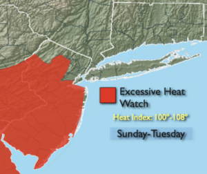
An Excessive Heat Watch is in effect through Tuesday for much of NJ. The combination of temperatures in the 90s and high dew points will result in a heat index of 100º or higher.
Stay Tuned.
Keep it here for a no nonsense, no hype forecast.
Today:
Spotty morning showers otherwise, hazy, warmer and more humid. Scattered afternoon storms. Highs in the lower to mid 80s. South to Southwest winds at 8-12mph.
Tonight:
Partly cloudy. Much warmer than recents nights. Muggy. Lows in the mid 70s in the City, the upper 60s inland. Light Northwest winds.
Saturday:
Hazy, hot and humid. Highs in the lower 90s. Heat Index 95º-100º.
Sunday:
Hazy, hot and humid. Highs in the mid 90s. Heat index around 100º.
Monday:
Hazy, hot and humid. Scattered afternoon storms. Highs in the mid 90s. Heat Index: 100º-105º
Tuesday:
Hazy, hot and humid. Highs in the lower 90s. Heat Index: 95º-102º.