Synopsis:
A weak front will push offshore this morning. Any spotty showers will end and the sun will return. It will be hot, but the humidity will drop during the afternoon. Most will notice a difference by late day.
Tonight will be more comfortable than recents nights under mostly clear skies.
Thursday and Friday will still be warm but it will be more tolerable. The sun will continue to dominate as high pressure influences the region.
The weather should cooperate this weekend. Saturday will be hazy, hot and humid as a bubble of heat works in from the Southwest. A weak front will work in by Sunday morning with spotty showers but the sun will quickly return with slightly lower humidity.
Stay Tuned.
Keep it here for a no nonsense, no hype forecast.
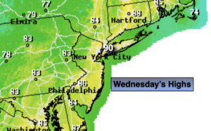
Today:
Spotty morning showers to mostly sunny skies. Hot. Becoming less humid during the afternoon. Highs around 90º. West winds at 8-12mph.
Tonight:
Mostly clear. More comfortable than recent nights. Lows in the upper 60s to around 70º in urban areas, the upper 50s and lower 60s inland. West winds less than 5mph.
Thursday:
Partly sunny. Less humid. Highs in the mid 80s.
Friday:
Partly sunny. Highs in the mid 80s.
Saturday:
Hazy, hot and humid. Highs in the lower 90s.
Sunday:
Spotty morning showers, otherwise partly sunny. Highs in the upper 80s.