Synopsis:
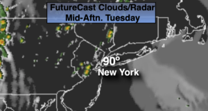
A Bermuda high will be in control through Wednesday. The heat and humidity will be the story. A mix of clouds and hazy sun is expected. Isolated afternoon showers or storms are possible. It will not be a washout and much of the time will be dry.
By Wednesday night a cool front will pass through bringing an end to the uncomfortable conditions.
Thursday and Friday will still be warm but the humidity will be lower. The sun will continue to dominate.
The heat will creep in back this weekend. At least the sun will shine!
Stay Tuned.
Keep it here for a no nonsense, no hype forecast.
Today:
Mostly sunny, hot and humid. Isolated PM storms. Highs around 90º. Cooler at the coast. South winds at 5-10mph.
Tonight:
Partly cloudy. Patchy fog, muggy and warm. Lows in the lower 70s in the City, the 60s inland. South winds less than 5mph.
Wednesday:
Hazy, hot and humid. Scattered PM showers/storms. Highs around 90º.
Thursday:
Partly sunny. Less humid. Highs in the mid 80s.
Friday:
Partly sunny. Highs in the mid to upper 80s.
Saturday:
Partly sunny and hot. Highs 85º-90º.