Synopsis:
High pressure over the Western Atlantic and a weakening surface and upper level low over West Virginia will cause a moist flow of air to ride up from the South. The result will be more clouds and higher humidity and temperatures through Father’s Day weekend. There will be times of sun. Each afternoon will feature the chance of scattered showers or storms. It will not be a washout and much of the time will be dry. I am not canceling my outdoor plans this weekend!
Summer Arrives at 5:44PM EDT Saturday.
The beginning of next week will be typical for our season of Summer. Warm and humid conditions are expected.
Stay Tuned.
Keep it here for a no nonsense, no hype forecast.
Today:
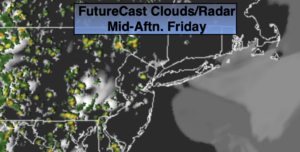
Sun and clouds. Scattered PM showers/storms. Humid. Highs around 80º.
Tonight:
Mostly cloudy. Patchy Fog. Muggy. Lows in the 60s throughout. South winds less than 5mph.
Saturday:
Sun and clouds. Warm and humid. Scattered PM showers/storms. Highs in the lower 80s.
Father’s Day:
Sun and clouds. Warm and humid. Scattered PM showers/storms. Highs in the mid 80s.
Monday:
Sun and clouds. Warm and humid. Scattered PM showers/storms. Highs in the mid to upper 80s.
Tuesday:
Mostly sunny. Hot and humid. Highs around 90º.