Synopsis:
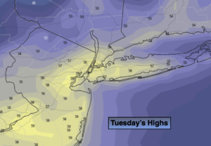
Another unseasonably cool airmass will move in from Canada today. Despite the sun, readings will remain mostly in the 50s with a gusty wind making feel even cooler.
Tonight will be chilly. Skies will be clear and patchy frost in possible in the ‘burbs.
Wednesday and Thursday will see moderating temperatures as the cold pool of air moves offshore and high pressure moves over the Mid-Atlantic coast. Skies will be mainly sunny. Readings will be near seasonal levels by Thursday (which is 70º).
If. you have been waiting for some warm weather. Your wish will be granted on Friday. Temperatures will flirt with 80º! as a pattern change finally looks to be taking shape. It’s about time.
The weekend looks decent at this time with mild temperatures and a decent amount of sunshine.
Stay Tuned.
Keep it here for a no nonsense, no hype forecast.
Today:
Partly sunny, breezy and chilly. Highs in the upper 50s. West to Northwest winds at 10-20mph with gusts to 30mph.
Tonight:
Clear with diminishing winds. Lows in the lower 40s in the City, the 30s inland with scattered frost. Northwest winds at 5-10mph.
Wednesday:
Sunny. Highs in the lower to mid 60s.
Thursday:
Partly sunny. More seasonal. Highs in the upper 60s.
Friday:
Partly sunny, much warmer. Chance of late day showers. Highs near 80º.
Saturday:
Partly sunny. Mild. Highs in the 70s.