Synopsis:
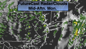
The week will start off a bit unsettled with a developing low moving through the Northeast today. On and off showers are likely. There will be dry times. It will be chilly.
Any showers this evening will end with skies becoming mostly clear. Scattered frost is possible in the ‘burbs.
Another unseasonably cool airmass will move in from Canada on Tuesday. Despite the sun readings will remain mostly in the 50s with a gusty wind making feel even cooler.
Wednesday and Thursday will see moderating temperatures as with wind turns to the South. Readings will be near seasonal levels by Thursday (which is 70º).
If. you have been waiting for some warm weather. Your wish will be granted on Friday. Temperatures will flirt with 80º! as a pattern change finally looks to be taking shape. It’s about time.
Stay Tuned.
Keep it here for a no nonsense, no hype forecast.
Today:
Mostly cloudy. On and off showers. Highs around 60º. Southwest winds increasing during the afternoon 10-20mph with higher gusts.
Tonight:
Early evening showers, otherwise becoming mostly clear and chilly. Lows near 40 in the City, the 30s inland with scattered frost. Northwest winds at 10-20mph and diminishing.
Tuesday:
Partly sunny, breezy and chilly. Highs in the upper 50s.
Wednesday:
Sunny. Milder. Highs in the mid 60s.
Thursday:
Partly sunny. Seasonal. Highs near 70º.
Friday:
Partly sunny, much warmer. Chance of late day showers. Highs near 80º.