Synopsis:
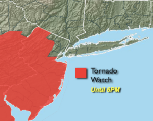
***TORNADO WATCH is in effect until 6pm for much of NJ*** Scattered severe thunderstorms this afternoon have the capability of producing a tornado. Please keep an eye to the sky and seek shelter immediately if threatening weather approaches. Flashlights and other essentials need to be ready if power is lost***
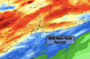
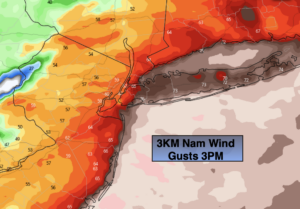
It will be a stormy Monday as a storm rides to our West and into the Great Lakes. Heavy rain and high winds are expected. One to three inches of rain is expected (2nd map). There maybe a lull in the rain for a few hours toward midday. Winds will gust between 50mph and 70mph (3rd map ). Power outages will occur with these wicked winds. I would prepare for possible outages.
There will be a brief break on Tuesday. Another round of showers is possible on Wednesday.
Thursday will be fair with cooler than average temperatures. On Friday, sun will give way to clouds. Spotty PM showers are possible.
Stay Tuned.
Keep it here for a no nonsense, no hype forecast.
Today:
Heavy rain and high winds. There maybe a lull in the rain toward midday. Highs in the upper 60s. South winds at 25-40mph with gusts between 50mph and 70mph.
Tonight:
Clearing skies with diminishing winds. Lows in the 40 throughout. West to Northwest winds diminishing to 10-15mph.
Tuesday:
Partly sunny. Highs in the upper 50s.
Wednesday:
Mostly cloudy with showers possible.. Highs near 50º.
Thursday:
Partly sunny. Highs in the mid 50s.
Friday:
Partly sunny. Slight chancer of PM Showers. Highs in the mid 50s.
***Please take “social distancing” seriously during this time. We will get through this.****