Synopsis:
High pressure over the Southeastern part of the country will be responsible for our tranquil conditions through Easter Sunday. It will be more seasonal under a mix of sun and clouds.
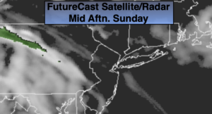
Clouds will thicken tonight and rain will arrive shortly after midnight from West to east as a large shield of rain works up from the Appalachians with an intensifying low.
Stormy conditions are likely on Monday as the storm rides to our West. Heavy rain and high winds are expected. It also will be balmy. Please be aware that power outages are a possibility with wind gusts between 50mph and 70mph.
There will be a brief break on Tuesday. Another round of showers is possible on Wednesday.
Thursday will be fair with cooler than average temperatures.
Stay Tuned.
Keep it here for a no nonsense, no hype forecast.
I would like to wish all of my followers a HAPPY EASTER! Easter maybe different this year, but the meaning true meaning of Easter remains a constant.
Easter Sunday:
Sun and clouds. Highs in the lower 60s. South to Southeast winds at 10-15mph, gusting up to 25mph during the afternoon.
Tonight:
Cloudy with rain developing around or shortly after midnight. Remaining mild. Lows in the 50s throughout. South winds increasing to 15-25mph with gusts to 35mph by daybreak.
Monday:
Heavy rain and high winds. Highs in the upper 60s.
Tuesday:
Partly sunny. Highs in the upper 50s.
Wednesday:
Mostly cloudy with showers possible.. Highs near 50º.
Thursday:
Partly sunny. Highs in the lower to mid 50s.
***Please take “social distancing” seriously during this time. We will get through this.****