Synopsis:
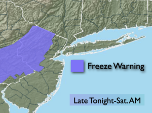
Scattered snow showers will end this evening. A cold pool of air will settle over the region tonight. A Freeze Warning is up for parts of Northern and Western NJ. Readings could drop a couple degrees below freezing in these areas. Skies will become mostly clear and winds will diminish some.
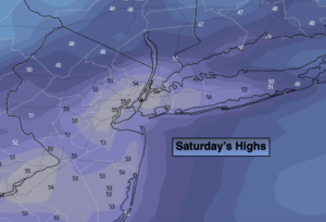
More tranquil conditions are expected for the weekend as high pressure dominates over the Southeast.. There will be a chill on Saturday despite the abundant sunshine. The winds ease some. A Fire Weather Watch has been posted for all of NJ for Saturday. The dry conditions and gusty winds could yield to wild fire potential. Please use caution with flammables outdoors.
Easter Sunday will be more seasonal under a mix of sun and clouds.
Rain is likely on Monday as a storm rides to our West. This track will also result in balmy temperatures.
Strong winds could be an issue.
There will be a brief break on Tuesday. Another round of wet weather is possible on Wednesday.
Stay Tuned.
Keep it here for a no nonsense, no hype forecast.
Tonight:
Becoming mostly clear. Lows in the upper 3os in the City, near freezing inland. West to Northwest winds at 15-25mph with gusts to 30mph, diminishing some late.
Saturday:
Sunny and breezy. Highs in the lower to mid 50s. West to Northwest winds at 10-20mph.
Easter Sunday:
Sun and clouds. Highs in the lower 60s.
Monday:
Rainy and windy. Highs in the upper 60s.
Tuesday:
Partly sunny. Highs in the upper 50s.
Wednesday:
Mostly cloudy with showers possible.. Highs in the upper 50s.
***Please take “social distancing” seriously during this time. We will get through this.****