Synopsis:
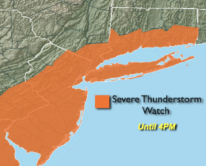
***Severe Thunderstorm Watch until 4PM for much of the tri-state area***
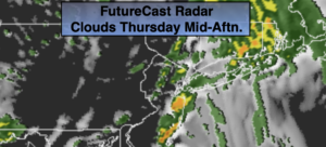
A cool front will move through the area during the afternoon. There will be times of sun. Please keep an eye to the sky for threatening weather conditions at this time. There is a chance that some of the storms may turn severe. The primary threat is damaging winds. The wind will increase dramatically by afternoon out of the West to Northwest gusting up to 45mph behind the front. A Wind Advisory is in effect for this afternoon and evening for the entire area. Readings will be a few degrees above the average high of 59º.
Much cooler air will move down from Canada for tonight and Friday on a gusty Northwest wind. Skies will be partly cloudy tonight. Friday may start off with some sun but the clouds will eventually win the battle. It will remain windy.
More tranquil conditions are expected for the weekend. There will be a chill on Saturday as the winds ease. Easter Sunday will be more seasonal. Both days will feature a mix of sun and clouds as high pressure dominates over the Southeast.
Rain is likely for the beginning of next week.
Stay Tuned.
Keep it here for a no nonsense, no hype forecast.
Today:
Spotty showers this morning. The second round of showers and storm will arrive from mid-day though mid afternoon. The sun will shine in between the rounds of showers. Becoming windy. Highs around 60º. Southeast winds becoming West to Northwest and increasing to 15-30mph with gusts to 45mph.
Tonight:
Partly cloudy. Lows around 40º in the City, the 30s inland. West winds at 15-30mph with gusts to 45mph during the evening.
Friday:
Partly sunny, windy and cooler. Highs in the lower 50s.
Saturday:
Mostly sunny. Highs in the lower to mid 50s.
Easter Sunday:
Sun to afternoon clouds. Highs near 60º.
Monday:
Rain likely. Highs in the 60s.
***Please take “social distancing” seriously during this time. We will get through this.****