Synopsis:
The beginning of the week will be bright and mild with weak high pressure over the tri-state. Readings will be above average by several degrees. The average high is 57º. A nice couple of days are on the way.
Rapidly moving fronts and weak areas of low pressure will keep Wednesday and Thursday unsettled with a chance of showers. It won’t be raining all of the time.
The week will end on a chilly note with the airmass moving in from Canada on Friday.
Stay Tuned.
Keep it here for a no nonsense, no hype forecast.
Today:
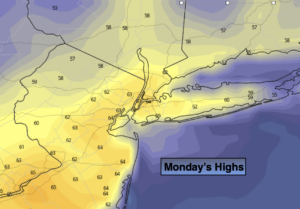
Sunny. Mild. Highs in the mid 60s. Northwest winds at 5-10mph.
Tonight:
Partly cloudy. Lows in the upper 40s in the City, the 30s inland. West wind less than 5mph.
Tuesday:
Partly sunny. Highs in the mid 60s.
Wednesday:
Mostly cloudy with scattered showers. Highs around 60º.
Thursday:
Mostly cloudy with scattered showers. Highs around 60º.
Friday:
Partly sunny, cooler. Highs in the lower to mid 50s.
***Please take “social distancing” seriously during this time. We will get through this.****