Synopsis:
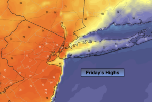
***Happy Spring*** A warm front over the area this morning is responsible for the areas of fog and showers. Once this front swings through by late morning balmy conditions are expected with readings rapidly getting into the 70s with a Southwest wind. It will be much cooler closer to the ocean. A mix of sun and clouds is expected later this afternoon along with spotty showers as a cool front approaches.
Bright and cooler weather will greet us for the weekend due to strong high pressure over the Northeast.
Monday’s forecast all depends on the track of a developing storm off the Mid-Atlantic coast. If the storm is close enough rain and even some wet snow is possible. If the storm stays offshore little if any precipitation will fall.
Stay Tuned.
Keep it here for a no nonsense, no hype forecast.
Today:
Areas of morning fog and showers giving way to a mix of some sun and clouds. Balmy. Slight chance of a shower later today. Highs well into the 70s. Much cooler over Long Island and Connecticut. Southwest winds at 10-20mph.
Tonight:
An evening shower or spot storm, otherwise clearing and breezy. Lows in the lower 40s in the City, the upper 30s inland. Southwest to Northwest winds at 10-20mph.
Saturday:
Mostly sunny. Cooler. Highs in the lower 50s.
Sunday:
Sunny. Chilly. Highs in the mid 40s.
Monday:
Cloudy with a chance of rain. The potential exists for some wet snow North and West. Highs around 40º.
Tuesday:
Mostly sunny. Seasonal. Highs around 50º.
***Please take “social distancing” seriously during this time. We will get through this.****