Synopsis:
Spotty showers are likely early tonight, otherwise skies will clear as a cool front moves off the coast. There is no true cold air behind this front and our balmy Winter continues. Above average temperatures will be with us through the end of the week. Wednesday and Thursday will feature mainly sunny skies as weak high pressure settles over the Northeast.
By Friday another cool front will approach the area. Morning showers will give way to afternoon sun. It’ll be warm.
Saturday will be bright with cooler temperatures but by no means will it be cold. By Sunday readings will finally be near the seasonal averages of the upper 40s as Canadian high pressure influences the region.
Spring officially arrives on March 19th.
Stay Tuned.
Keep it here for a no nonsense, no hype forecast.
Tonight:
Scattered showers early, otherwise clearing skies. Lows in the mid 40s in the City, the 30s inland. Southwest to Northwest winds at 8-12mph.
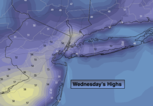
Wednesday:
Mostly sunny and mild. Highs in the mid 50s. North to East winds at 5-10mph.
Thursday:
Partly sunny. Highs in the lower to mid 50s.
Friday:
Morning showers will give way to afternoon sun. Balmy. Highs in the mid 60s.
Saturday:
Mostly sunny. Highs in the lower 50s.
Sunday:
Partly sunny. Highs in the mid to upper 40s.