Synopsis:
February has made an appearance for the next 48 hours. Extensive cold high pressure with a flow out of Canada will result in below average temperatures through tomorrow. A mix of sun and clouds is expected for today as a storm moves off the North Carolina coast. Amazingly, North Carolina will receive accumulating snow later today while our area continues with a snow drought.
By the weekend the large dome of high pressure will slip off the coast resulting in a Southwest flow. This will allow the mercury to once again go above average.
The beginning of the week will continue with our Spring preview of the weekend.
Stay Tuned.
Keep it here for a no nonsense, no hype forecast.
Today:
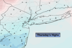
A mix of sun and clouds. Colder. Highs in the mid 30s. Northwest winds at 8-12mph.
Tonight:
Clear. Cold. Lows in the lower to mid 20s in the City, 10º-20º inland. Northwest winds 10-15mph.
Friday:
Sunny. Chilly. Highs in the mid 30s.
Saturday:
Sunny. Milder. Highs in the upper 40s.
Sunday:
Sunny. Highs around 50º.
Monday:
Partly sunny. Mild. Highs in the lower to mid 50s.