Synopsis:
A cool front will move through the area overnight with scattered showers. Once the front passes skies will clear late.
The sun will dominate for the mid to late week period as extensive high pressure dominates the Eastern one half of the nation. A cold push will arrive Thursday and Friday with readings below average.
By the weekend the large dome of high pressure will slip off the coast resulting in a Southwest flow. This will allow the mercury to once again go above average (the average high is 42º). Wall to wall sunshine will remain.
The snow drought continues as the weather pattern is not favorable for cold and nearby storm formation.
Stay Tuned.
Keep it here for a no nonsense, no hype forecast.
Tonight:
Scattered showers early tonight. Clearing late. Lows in the upper 30s in the City, near freezing inland. Southwest to Northwest winds at 8-12mph.
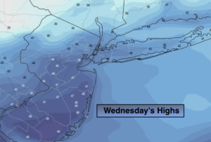
Wednesday:
Mostly sunny. Highs in the mid 40s. Northwest winds at 10-20mph.
Thursday:
Mostly sunny and colder. Highs in the lower 30s.
Friday:
Sunny. Chilly. Highs in the mid 30s.
Saturday:
Sunny. Milder. Highs in the upper 40s.
Sunday:
Sunny. Highs around 50º.