Synopsis:
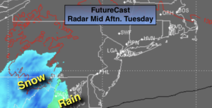
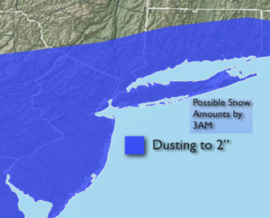
Today will be mostly cloudy. A low will develop over Eastern Tennessee and move to the Virginia Capes by Tuesday evening. Light rain and or light wet snow will break out from Southwest to Northeast later in the afternoon and evening. Since the storm will be fast moving and just far enough offshore it doesn’t look like a big deal. A few hours of light snow is possible early tonight. The potential is there for a dusting to up to 2″ of snow. The highest amounts are looking to be South and East of the City. JMW will continue to monitor for any shift in the precipitation shield.
Wednesday will be windy and colder behind departing storm in Eastern Canada. Flurries are possible.
Thursday will be bright and seasonal. The average high temperatures are in the upper 30s.
On Friday strong high pressure will move off the coast. A return Southwesterly flow will cause readings to pop into the 50s. In fact, readings will reach the Spring-like 60s on Saturday. A few showers are possible as well.
Stay Tuned.
Keep it here for a no hype, no nonsense forecast.
Today:
Increasing clouds. Chance of rain and snow showers later in the day, especially South and East of the City. Highs in the lower 40s. West to East winds at 5mph.
Tonight:
The potential for a few hours of snow. Lows around freezing in the City, the 20s inland. Northeast to West winds at 5-10mph.
Wednesday:
Sun and clouds. Scattered flurries, windy and cold. Highs in the upper 30s.
Thursday:
Sunny and seasonal. Highs in the upper 30s.
Friday:
Sun to clouds. Much milder. Highs in the lower 50s.
Saturday:
Mostly cloudy and warm with spotty showers. Highs in the lower 60s.