Synopsis:.
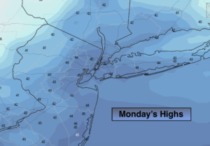
An early morning flurry is possible (some areas received a coating of snow overnight) otherwise clouds will give way to sun. It”ll be bright with above average temperatures as high pressure works in from the Ohio Valley.
Tonight will be clear and chilly.
Tuesday will start off sunny but clouds will quickly move in. A low will develop over Virginia and move rapidly while intensifying off our coast. Snow showers are possible by dark. Since the storm will be fast moving and just far enough offshore it doesn’t look like a big deal. A few hours of light snow is possible for coastal areas. This region has the potential to receive up to a coating by late Tuesday night.
Wednesday will be windy and colder behind departing storm in Eastern Canada. Flurries are possible.
Thursday will be bright and seasonal. The average high temperatures are in the upper 30s.
On Friday strong high pressure will move off the coast. A return Southwesterly flow will cause readings to pop into the 50s. In fact, readings may reach the 60s by Saturday with rain.
Stay Tuned.
Keep it here for a no hype, no nonsense forecast.
Today:
Early morning flurry East otherwise clouds will. give way to mostly sunny skies. It’ll be mild with highs in the mid 40s. West winds at 10-15mph.
Tonight:
Clear and cold. Lows around freezing in the City, the 20s inland. Northwest to West winds at 5-10mph.
Tuesday:
Increasing clouds. Chance of snow showers by dark. The is a low potential for a period of light snow for a few hours at night for coastal areas. Highs in the lower 40s.
Wednesday:
Sun and clouds. Scattered flurries, windy and cold. Highs in the upper 30s.
Thursday:
Sunny and seasonal. Highs in the upper 30s.
Friday:
Sun to clouds. Much milder. Highs in the mid 50s.