Synopsis:.
The low that gave the region rain and freezing rain will move off the coast tonight. Any spotty precipitation will end this evening. There will be icy conditions overnight despite the clearing skies as readings fall below freezing. Any moisture on surfaces will become slick if untreated.
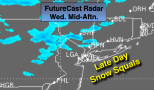
Wednesday the sun will return. An Arctic front will move in during the afternoon. Scattered snow showers and snow squalls are possible later in the day. Any snow squall can produce a brief (5-10 minutes) period of heavy snow, high winds and low visibility. Not all areas will experience the quick moving snow. This front will usher in a bitter blast Wednesday night along with high winds. Wind chills will be near 0º.
Thursday will be frigid, despite the sunshine. Highs will be well below freezing as the cold high move toward the area. Friday will be bright and cold with readings near freezing.
The weather will cooperate this weekend. Strong high pressure will be over the Northeast. Abundant sunshine and moderating temperatures can be expected.
Stay Tuned.
Keep it here for a no hype, no nonsense forecast.
Tonight:
Clearing skies. Lows around 30º in the City, the 20s inland. Northwest winds at 10-15mph.
Wednesday:
Partly sunny. Scattered snow showers and snow squalls are likely later in the day. Becoming windy during the mid afternoon. Highs in the upper 30s. West to Northwest winds increasing to 15-25mph late.
Thursday:
Sunny and frigid. Highs only in the mid 20s.
Friday:
Sunny, cold. Highs near freezing.
Saturday:
Mostly sunny. Highs in the mid 30s.
Sunday:
Mostly sunny, not as cold. Highs in the mid 40s. .